


Similar products
Similar products


$100 min
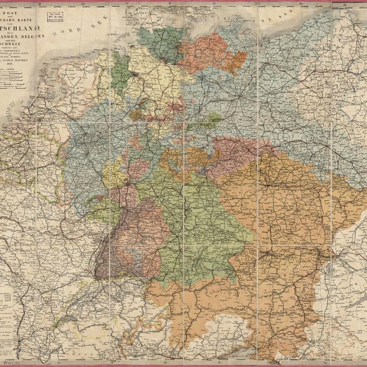
Wholesale Und Eisenbahn-Karte Von Deutschland, Den Niederlanden, Belgien Und Der Schweiz 1855
WSP
$73.95 MSRP
Shipping & policies
- Estimated delivery Jan 28-Feb 5
Free and easy returns. Learn more
With Faire, shop unique wholesale products for your store from brands like Relic Map Co. and more.
Description
Old road map of Benelux Countries, Central Europe, Europe, Central, Germany, Switzerland. Created by Millard Fillmore, Germany) Justus Perthes (Firm : Gotha in 1855. * Post-road/railroad map of Central Europe and adjacent regions. * Covers Germany, Benelux, Switzerland, Austria, Poland, and Hungary. * The component German states/principalities and adjacent countries are shown in distinctive coloration. * When affixed to the cloth backing the map sheet was sectioned to 18 panels. * Handwritten (cursive script) inked identification statement on right-hand cover panel: German post & r. roads--1855--Millard Fillmore 1856. * This map has some imperfections: use-worn, foxed on cloth backing (verso), and edged in pink cloth hem. We'll do our best to restore the image before printing. * Includes notes and 5 bar scales.
Details
SKU: 6572_2018588038_23.8x28.5 Made in United States Weight: 99.79 g (3.52 oz)


