


Similar products
Similar products


3.7 ()
$200 min
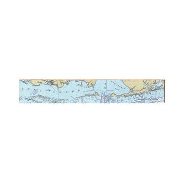
Wholesale Jacksonville to Daytona Offshore Fish and Dive Chart 125F
WSP
$32.95 MSRP
Shipping & policies
- Estimated delivery Apr 22-29
Free and easy returns. Learn more
With Faire, shop unique wholesale products for your store from brands like Waterproof Charts and more.
Description
Don’t hit the offshore waters from Jacksonville to Daytona without these fishing charts. Brilliantly colored, this Jacksonville fishing chart employs new graphic features to describe the deepwater fishing and diving opportunities of offshore Northeast Florida. The north side covers from the Grand Banks (offshore Darien Georgia) south to the St Augustine Inlet and east past the edge of the beautifully defined continental shelf. The south side details the St Augustine Grounds and reefs and continues south past Daytona Beach to south of Ponce Inlet.
Details
SKU: 125F Made in United States Weight: 45.36 g (1.6 oz) Dimensions: 96.5 x 63.5 x 0 cm (38 x 25 x 0 in)


Ratings and reviews
Relevance
3.7
Brand rating ()
5
5
1
1
4
4
1
1
3
3
0
0
2
2
1
1
1
1
0
0
No reviews for Jacksonville to Daytona Offshore Fish and Dive Chart 125F yet.
Reviews for similar products from Waterproof Charts: Map

We ordered 6 of two differnt kinds of maps. received 12 of one style, 0 of the other.
We ordered 6 of two differnt kinds of maps. received 12 of one style, 0 of the other.
14 feb 2025 • Cindy • Port St. Joe, FL, United States