


Similar products
Similar products


3.7 ()
$200 min
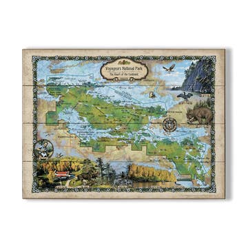
Wholesale Everglades City Area Large Print Navigation Chart 40E
WSP
$32.95 MSRP
Shipping & policies
- Estimated delivery May 4-11
Free and easy returns. Learn more
With Faire, shop unique wholesale products for your store from brands like Waterproof Charts and more.
Description
Detailed coverage of the 10,000 Islands area from Tripod Key to Chatham Bend. Includes Coon Key, Dismal Key, Port of the Islands and all the waterways south of Route 41. Compiled from NOAA charts and USGS Pictomaps this chart features canoe trails, inside small boat routes, updated beaches and campgrounds, GPS Waypoints and important areas of recent shoaling. Get the most out of your boating adventures around Everglades City with this navigation map.
Details
SKU: 40E Made in United States Weight: 45.36 g (1.6 oz)


Ratings and reviews
Relevance
3.7
Brand rating ()
5
5
1
1
4
4
1
1
3
3
0
0
2
2
1
1
1
1
0
0
No reviews for Everglades City Area Large Print Navigation Chart 40E yet.
Reviews for similar products from Waterproof Charts: Map

We ordered 6 of two differnt kinds of maps. received 12 of one style, 0 of the other.
We ordered 6 of two differnt kinds of maps. received 12 of one style, 0 of the other.
14 feb 2025 • Cindy • Port St. Joe, FL, United States