


Similar products
Similar products


5.0 ()
$150 min
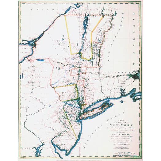
Wholesale New York & New Jersey in 1776 - Historical Map
WSP
$47.50 MSRP
Shipping & policies
- Estimated delivery Jul 1-10
Free and easy returns. Learn more
With Faire, shop unique wholesale products for your store from brands like Historic Urban Plans, Inc. and more.
Description
25 3/4" x 20 1/2". This superb map drawn by C. J. Sauthier is a detailed record of urban settlement in the northeast at the time of the Revolutionary War. It includes the area between Boston on the east and Cayuga Lake on the west, centered on the Hudson River Valley region and showing the roads, forts, rivers, mountains, and lakes with great accuracy.
Details
SKU: NYNJ776 Made in United States


Ratings and reviews
Relevance
5.0
Brand rating ()
5
5
4
4
4
4
0
0
3
3
0
0
2
2
0
0
1
1
0
0
No reviews for New York & New Jersey in 1776 - Historical Map yet.
Reviews for similar products from Historic Urban Plans, Inc.: Map

thank you the maps are beautiful!!
thank you the maps are beautiful!!
Jul 25, 2024 • Nic • Mississauga, ON, Canada

Colorful and interesting maps. Second order placed. Very satisfied!
Colorful and interesting maps. Second order placed. Very satisfied!
Jul 24, 2020 • Zina • Port Orchard, WA, United States

I can't wait to hang these in my shop. Colorful, great quality!!
I can't wait to hang these in my shop. Colorful, great quality!!
Sep 26, 2019 • Zina • Port Orchard, WA, United States

