


Similar products
Similar products


$100 min
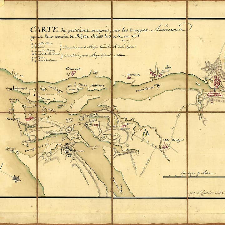
Wholesale Carte Des Positions Occupeés Par Les Trouppes Américaines Apres Leur Retraite De Rhode Island Le 30 Aout 1778
WSP
$34.95 MSRP
Shipping & policies
- Estimated delivery Jan 14-23
Free and easy returns. Learn more
With Faire, shop unique wholesale products for your store from brands like Relic Map Co. and more.
Description
Old map of Narragansett Bay Region, Rhode Island, United States. Created by Michel Capitaine Du Chesnoy, Marie Joseph Paul Yves Roch Gilbert Du Motier Lafayette in 1778. * Relief shown by hachures. * Some place names in English. * Oriented with north toward the lower right. * Pen-and-ink and watercolor. * Sectioned and mounted on cloth backing. * Includes descriptive index to defenses. * On label affixed to verso of backing: No. 132. Carte des positions occupeés par les trouppes Américaines le 30 Aoust 1778. * Gift; Mr. and Mrs. H.F. Lenfest; Jan. 2000 Map Subjects Defenses Early Works To 1800 Maps Manuscript Narragansett Bay Region Narragansett Bay Region (R.I.) Rhode Island Rhode Island Battle Of R.I. United States Michel Capitaine Du Chesnoy Marie Joseph Paul Yves Roch Gilbert Du Motier Lafayette 1778
Details
SKU: 4248_00555648_15.7x20.8 Made in United States Weight: 99.79 g (3.52 oz)


