


Similar products
Similar products


Shipping & policies
- Estimated delivery Mar 18-30
Free and easy returns. Learn more
With Faire, shop unique wholesale products for your store from brands like XPLORER MAPS and more.
Description
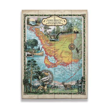
Hand-Drawn, 24"x18" full-color map, lithographic print in durable, full-color Illustrated tube. This hand-drawn, custom, and ORIGINAL illustrated map of the park is the result of a collaborative partnership with the North Cascades Institute. Please visit www.ncascades.org to learn more about their mission to connect people, nature, and community through Cascadia’s natural and cultural history. Xplorer Maps donates a portion of all proceeds to NCI in perpetuity from the sale of these maps.
Details
SKU: MAP_OLY Made in United States Color: Multi-Colored Theme: Travel & Adventure Weight: 453.59 g (1 lb) Dimensions: 61 x 45.7 cm (24 x 18 in)


Ratings and reviews
Relevance
4.9
Brand rating ()
5
5
91
91
4
4
2
2
3
3
2
2
2
2
0
0
1
1
0
0
5.0
Quality of products
5.0
Fulfillment
5.0
Communication

Olympic National Park Hand-Drawn Map
These Maps are a favorite of my customers and a popular selling item, I'm proud to have them in my store!
These Maps are a favorite of my customers and a popular selling item, I'm proud to have them in my store!
Feb 9, 2026 • Julie • Port Angeles, WA, United States
Reviews for similar products from XPLORER MAPS: Map

Great quality maps. We ordered a lot and they came quick. All packaged very well.
Great quality maps. We ordered a lot and they came quick. All packaged very well.
Jan 21, 2021 • Desiree • Moab, UT, United States

Not only are the maps beautiful to look at but they are also very detailed and accurate.
Not only are the maps beautiful to look at but they are also very detailed and accurate.
May 18, 2021 • Susan • East Glacier Park Village, MT, United States
