


Similar products
Similar products


£75 min
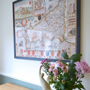
Wholesale Barker's Map of Washington County, Pennsylvania : from Actual Surveys (Map of Washington County, Pennsylvania) 1856
WSP
£151.00 RRP
Shipping & policies
- Estimated delivery on Jan 21–29
Free and easy returns. Learn more
With Faire, shop unique wholesale products for your shop from brands like Relic Map Co. and more.
Description
Old map of Beallsville, California, California (Washington County), Canonsburg, Centerville, Centerville (Washington County), Claysville, Coal Center, Cross Creek, Monongahela, Pennsylvania, United States, Washington, Washington (Washington County), Washington County, West Alexander, West Middletown. Created by Wm. J. (William J.) Barker, A. R. Day, James M. Sherman, Wm. Schuchman & Bro. Lith in 1856. * General-content county map also showing rural buildings with householders' names; householders' names also given in the village/borough/city insets. * Hand col. to distinguish townships. * Originally printed on 2 sheets (east/west, later conjoined).
Details
SKU: 35071_2012592223_42.2x52.6 Made in United States Weight: 99.79 g (3.52 oz)


