Map Marketing Limited – wholesale Map – Berkshire, Buckinghamshire and Oxfordshire Postcode Wall Map0
Map Marketing Limited – wholesale Map – Berkshire, Buckinghamshire and Oxfordshire Postcode Wall Map1
Map Marketing Limited – wholesale Map – Berkshire, Buckinghamshire and Oxfordshire Postcode Wall Map2
Map Marketing Limited – wholesale Map – Berkshire, Buckinghamshire and Oxfordshire Postcode Wall Map3
Map Marketing Limited – wholesale Map – Berkshire, Buckinghamshire and Oxfordshire Postcode Wall Map4
Map Marketing Limited – wholesale Map – Berkshire, Buckinghamshire and Oxfordshire Postcode Wall Map5
Map Marketing Limited – wholesale Map – Berkshire, Buckinghamshire and Oxfordshire Postcode Wall Map6
Map Marketing Limited – wholesale Map – Berkshire, Buckinghamshire and Oxfordshire Postcode Wall Map7
Map Marketing Limited – wholesale Map – Berkshire, Buckinghamshire and Oxfordshire Postcode Wall Map8
Map Marketing Limited – wholesale Map – Berkshire, Buckinghamshire and Oxfordshire Postcode Wall Map
Avatar

Map Marketing Limited

£100.00 min

Wholesale Berkshire, Buckinghamshire and Oxfordshire Postcode Wall Map

Wholesale Berkshire, Buckinghamshire and Oxfordshire Postcode Wall Map

Wholesale Berkshire, Buckinghamshire and Oxfordshire Postcode Wall Map

Wholesale Berkshire, Buckinghamshire and Oxfordshire Postcode Wall Map

WSP

£23.85 RRP

Shipping & policies

  • Estimated delivery Sept 1⁠–⁠11
  • Ships from United Kingdom

  • Free and easy returns. Learn more

With Faire, shop unique wholesale products for your shop from brands like Map Marketing Limited and more.


Description

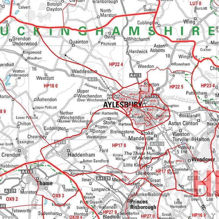
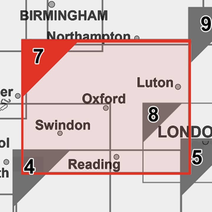
Sector Sheet 7: Berkshire, Buckinghamshire & Oxfordshire Set on Berkshire, Buckinghamshire and Oxfordshire, this postcode sector map is seventh of 37 pre-defined map sheets that covers the UK displaying all of the first part of the postcode and the first number of the second part, or Inward Code, at a scale of an inch to 2.4 miles. Within this wide area you get to see postcode sector level information for Reading, Oxford and more the area covered includes: North: Stratford-upon-Avon South: Basingstoke East: Corsham West: Harrow This Sector map includes all of the postcode changes in the most recent Royal Mail Postcode Update. Area, District and Sector boundaries and numbers/letters are shown in red with County and Unitary Authority boundaries presented in green.


Details

SKU: S7P Made in United Kingdom Weight: 0 g (0 oz)


The best selection of brands for your shop, all in one place

The best selection of brands for your shop, all in one place

The best selection of brands for your shop, all in one place

The best selection of brands for your shop, all in one place


Company

  • About us

  • Newsroom

  • Careers

  • Affiliates

  • Blog

  • Explore

  • Help centre

  • Open with Faire

  • Faire Markets

  • Sell on Faire

  • POS integration

  • InstagramFacebookX icon

    ©2025 Faire Wholesale, Inc.

    Terms of Service

    •

    Privacy Policy

    •

    Cookie policy

    •

    IP policy

    •

    Accessibility Policy

    •

    Sitemap

    Faire Logo
    Search
    Languages

    EN

    BlogSell on Faire
    Join free
    Skip to main content
    Visa Icon
    MasterCard Icon
    Amex Icon
    Discover Icon
    Diners Icon