


Similar products
Similar products


5.0 ()
£74.67 min
Wholesale 1957 Historical Map Of Maryland Eastern Shore & Chesapeake
Wholesale 1957 Historical Map Of Maryland Eastern Shore & Chesapeake
Wholesale 1957 Historical Map Of Maryland Eastern Shore & Chesapeake
Wholesale 1957 Historical Map Of Maryland Eastern Shore & Chesapeake
WSP
£37.33 RRP
Shipping & policies
- Estimated delivery on Dec 18–30
Free and easy returns. Learn more
With Faire, shop unique wholesale products for your shop from brands like Historic Pictoric and more.
Description
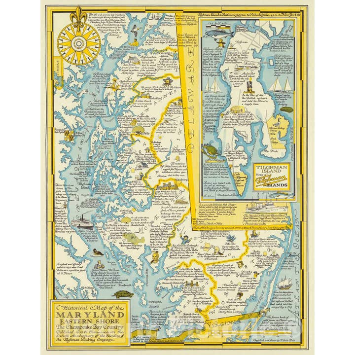
Historical Map of the Maryland Eastern Shore, the Chesapeake Bay Country. Published 1957 to Commemorate the Sixtieth Anniversary of the Founding of the Tilghman Packing Company. (inset) Tilghman Island. | Historical Map of the Maryland Eastern Shore, the Chesapeake Bay Country. Published 1957 to Commemorate the Sixtieth Anniversary of the Founding of the Tilghman Packing Company. |
Details
Made in United States


Ratings and reviews
Relevance
5.0
Brand rating ()
5
5
1
1
4
4
0
0
3
3
0
0
2
2
0
0
1
1
0
0
No reviews for 1957 Historical Map Of Maryland Eastern Shore & Chesapeake yet.
Reviews for similar products from Historic Pictoric: Map

Excellent
Excellent
11 sept. 2025 • Ralph • Williamsburg, VA, United States

Excellent
Excellent
11 sept. 2025 • Ralph • Williamsburg, VA, United States

Excellent
Excellent
11 sept. 2025 • Ralph • Williamsburg, VA, United States

Excellent
Excellent
11 sept. 2025 • Ralph • Williamsburg, VA, United States

